
 Trying to add a payment method? You can do this on the


QuickTake:
The journey to the lake takes you down Highway 31, one of loneliest and most spectacular paved roads in Oregon.
Escape to an oasis in Oregon’s high desert. Summer Lake is a three-hour drive from Eugene, but it’s a different world — a plausible backdrop for a movie set in the Old West, the Sahara or even Mars.
I’m going to recommend a three-day trip that includes a world-class birding oasis, a stay at Summer Lake Hot Springs, and a hike on Winter Ridge.

John C. Fremont named the landmarks here in 1843 while exploring the West with Kit Carson. They headed south from The Dalles toward California with a troop of federal soldiers and a cannon.
On Dec. 16 they crested a snowy ridge and saw a sunny alkali lake in the desert 2,700 feet below. Voilà: Winter Ridge and Summer Lake.
The trip is easier today, and takes you on one of loneliest and most spectacular paved roads in Oregon. Heading south on Highway 97 from Bend, look for Highway 31. It veers away from the pine forests of central Oregon at a junction near LaPine. Soon you’re in sagebrush country under a wide-open sky. After 48 miles, drive slowly through the hamlet of Silver Lake, so you don’t miss it altogether.
Another 13 miles over Picture Rock Pass takes you to the Summer Lake Store, a wild West outpost. When I walked in, the grizzled old-timer behind the counter said, “Ice cream’s on the left.”
I asked, “Do you sell the $10 parking permits for the Summer Lake refuge?”
This launched him into a tirade about far-off government bureaucrats. Eventually he told me no. You have to buy the parking permits online. And because the wifi is terrible at Summer Lake, you should buy them before leaving home, from the website.
The store owner grumbled, “But you could just put a piece of white paper on your dashboard, much as they bother to check.”
It’s also true that the best birding is from your car, so you hardly need to park at all.
Another mile down the highway you’ll see the Lodge at Summer Lake on your right. Stop here for lunch, because it has the only restaurant for miles. A “Rubin” sandwich with fries, soup or salad will set you back $13.50.
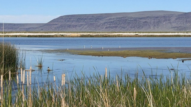
Now it’s time to go birding. Be warned that autumn is hunting season as well as birding season. Expect pickup trucks and a few bangs.
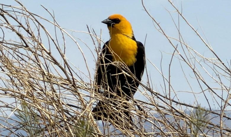
The entrance to the Summer Lake Wildlife Area is across the road from the Lodge at Summer Lake. Since 1944 the Oregon Department of Fish and Wildlife has bought 19,000 acres of marshland where the Ana River meanders into an alkali-rimmed lake with no outlet other than evaporation. Great flocks of white pelicans and Canada geese arrive here in September and October, on their way to Central America from the Arctic. Herons, egrets and terns are common. Bald eagles, ducks and swans remain in the winter.
Drive through the refuge headquarters compound, following “Wildlife Viewing Loop” pointers onto a gravel road. At a T-shaped junction after 1.6 miles, turn right for 0.9 mile to the Windbreak Campground, which consists of a gravel parking lot with outhouses and garbage cans.
If you have that $10 parking permit, you could camp here for free, but it’s windy and barren. My recommendation: Stay two nights in comfort at Summer Lake Hot Springs, and just go for a drive through the wildlife refuge. Start by driving out the Windbreak Dike 2.3 miles to the bridge where the Ana River enters Summer Lake.

The dike is a gravel road that’s gated closed most of the year but is open to vehicles during hunting season. Alongside the dike are some of the birdiest wetlands in the world.
Bring binoculars to tell the difference between avocets (curved beaks), stilts (straight) and ruddy ducks (bills). Why are little birds spinning in circles? Phalaropes stir up bugs with their feet.
After touring Windbreak Dike, drive through the rest of the refuge, following “Wildlife Viewing Loop” signs for 10.5 gravel miles. At the halfway point, detour left half a mile to the abandoned River Ranch, where a family of barn owls nests inside a scenic old barn.
After touring the refuge loop, drive Highway 31 south along the lakeshore 22 miles to Summer Lake Hot Springs. The sign for this funky old resort blew down in a “bomb cyclone” last year, so keep on the lookout for a driveway on the left near milepost 92. An etched board on a fencepost warns, “No Day Use. Reservations Only.”

The old hippie owner of the place realized when the sign blew down that he didn’t need publicity, and he didn’t want drop-ins. His business peaks during Nevada’s Burning Man festival, when 1,000 fans come to camp.
To soak in the various pools of Summer Lake Hot Springs, you have to reserve an overnight spot online at summerlakehotsprings.com before you go.
There are a dozen rustic cabins for about $150 a night. You can also camp for $25 per person per night, and that gives you bathing privileges, too. Bring your own food and bedding.
The main pool, in a 1928 bath house, has changing booths, a room with a hot toilet, hot showers, a lot of old graffiti and a faint sulfur smell. One of the rooftop air vents blew off in the bomb cyclone, leaving a hole to the sky. Behind this historic sheet metal shed, three rock-lined outdoor pools are even hotter.

Nudity is allowed from 9 p.m. to 7 a.m. These are also the hours for stargazing. Summer Lake is in the middle of the world’s largest dark sky sanctuary. The Milky Way yawns from one horizon to the other.
The sun comes up with a vengeance at Summer Lake, so you don’t want to linger in a tent or cabin that lacks air conditioning. Instead go for a hike where it’s cooler, atop Winter Ridge.
For the hike, drive back 5 miles on Highway 31 to milepost 87. Turn left on gravel Road 29 at a sign for Government Harvey Pass and drive 9.5 miles, climbing with spectacular views, up to a T-shaped junction at the pass. Turn right on gravel Road 2901 for 2.6 miles to a sign for Currier Spring and turn right on Road 033 for 0.4 miles. Just beyond the horse campground and the railed spring, park on the shoulder near a wooden trailhead sign on the right that’s hard to read.

The path that starts here climbs gradually through a high-elevation forest of ponderosa pine and quaking aspen. Summer wildflowers up here include red paintbrush, purple penstemon, blue lupine, white yarrow and arrowleaf balsamroot (a wild yellow sunflower).
After 0.3 miles you’ll reach a big sign at the junction with the Fremont Trail, a long-range National Recreation Trail that runs the length of Winter Ridge, almost all the way from Silver Lake to Lakeview. The Fremont Trail is lightly used, but is maintained for equestrians and is part of the Oregon Timber Trail, a mountain bike route across the state.
You could hike to the left along the Fremont Trail for 1.4 miles to a nice viewpoint, but honestly, an equally amazing view is much closer. From the signpost at the trail junction, simply walk 150 feet straight ahead.
You’ll suddenly emerge from the woods at a rock outcrop beside the gargantuan cliff of Winter Ridge.

Thousands of feet below, dust storms swirl alkali clouds from the Summer Lake playa. A series of bluish horizons retreat into the distance toward Steens Mountain.
John C. Fremont explored this remote corner of the Old West at an awkward time of year, in December. He liked it anyway. Today the wild vastness of Summer Lake and Winter Ridge seem even more precious.
And hey, Fremont didn’t even know about the hot springs.

